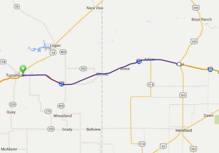
5th May 2016 Tucumcari, NM to Vega, Tx 120.1 kms - 74.6 miles Up = 462m - Down = 477m
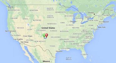
5th May 2016 - Tucumcari, New Mexico to Vega, Texas. We seem to have been riding through New Mexico forever!! However, today sees the end of our travel across our third state, New Mexico. While we will ride through 11 States on this journey - I have had a glimpse at the overall map - and suddenly I realise just how much progress we have made!! I think when we reach Oklahoma City we will be about half-way - and we are closing in on that mark!!
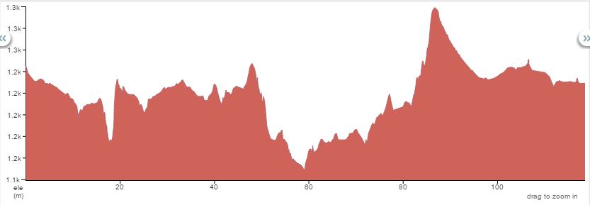
At 1200 metres above sea-level we are still pretty high up as we travel through these plains. The elevation profile above looks pretty dramatic - but if you look at the side scale it only covers about 100m in height so it was really a pretty flat ride.
Just under half way into our ride we reached the border with Texas - so move into our 4th State. Not that we will be in Texas for many days as we are crossing at what is called "the pan-handle" - the very top narrow part. Incidentally, on our drive back to LA after the ride we went across the bottom of Texas - and it is a very wide State at end!
It was a crisp 47 this morning, but did warm up to the mid 80's (around about 26 - 28C) which was lovely cycling weather. They don't get much rain in this part of the country so we are lucky in that respect - but we are getting closer to "tornado" regions so I was constantly checking the weather and we would scan the skies for any changes in the cloud formations. Tucumcari KOA had been a nice spot to camp – yet we had all breakfasted and were on the road by 7:45 am. The little nip in the air – made us wear sleeves to start with – but they were to come off mid-morning as the sun got hotter in the clear blue skies.
We turned right onto Route 66 immediately out of the campground gates and stayed on this for about 20 miles until we arrived in the town of San Hon. By now, we were not disappointed to find this was like so many of the pretty derelict towns along Route 66 - these towns all look so sad!.
We went onto the I-40 here and had a lovely wide shoulder, and the “normal” amount of traffic – mainly trucks, but a good deal of what Australians would call “Grey Nomads”, here called “Snow Birds” – with their HUGE fifth wheeler rigs (mainly) or long caravans. There don't seem to be many motorhomes and campervans here - mainly these very big units. From our enquiries they are a lot less expensive than we pay in Australia - all components really - the big "truck like utes" that pull them, the caravan/trailer itself, and particularly the cost of petrol (gas) for putting in the towing vehicles. We have been paying around $2.05 per gallon - which = 3.8 litres!!
I think since we entered New Mexico about 355 miles ago we have been seeing signs about “Russell’s Truck Stop”. With Annie and Don having a son with this name – we finally came across a "take next exit" sign for this - so we had to go in. Oddly with all the signs we had been seeing for the last 5 days, on the actual off-ramp there was no sign so Pat went ahead as it was across the road to be sure we were at the right place.
What a great spot – there was a 30 car museum as well as hundreds of other curios. The toilets were quirky “Elvis” and “Marilyn” – there were many Coca-Cola curios, and the number of replica trucks, cars etc etc had to be seen to be believed! We had “early” lunch here – 3 miles from the border where we would lose an hour as we entered a different time zone.
Annie’s front tyre didn’t feel that good when she left Russell’s – so we pumped it up and hoped she would make it to the border. Sadly she didn’t, so another roadside repair was done.
Crossing a border is always fun - it feels like we are making progress and we look forward to see what photo opportunities we will have at a border sign.
Immediately in Texas, the I-40 became a concrete road – and the bikes really run well on it. The shoulder is still wide and was a lot “cleaner” of debris compared to what we had come across. We did find the volume of the road noise increased on this surface and was quite a "screech". It made me think this must have been how the "musical" road must have been constructed of different surfaces to make the different tones - although I hadn't noticed any difference when I biked it.
Suddenly the land seemed much more productive and there was cattle in the paddocks before we came across very large paddocks of wheat, barley etc. There were also lots of different shades of wildflowers alongside the road too.
Between 80 and 90 kms into the journey we had the only real hill climb of the day and we could see windmills in the distance to the left which we gradually wound our way around to. For the remaining 30 kms into Vega the left hand side of the road has been nothing but windmills – and the right hand side – nothing but crops.
We passed the sign to the town of Adrian which is noted as the half-way point on Route 66. We leave Route 66 when we get to Oklahoma City.
Gail and her husband welcomed us to their Walnut RV Park in Vega, and apparently had been following our journey on facebook. They had a beautiful grassy site for us under a “Black Walnut” tree – and everything was set-up in no time. We had a wander around the town of Vega - not a lot happening but with the increased agricultural activity in the area the businesses seemed a little more vibrant than in some of the previous towns of this size. With a population of just under 1000 there was still a good deal of abandoned buildings - but we did find a nice bustling cafe to have dinner at.